Train and bus routes
The Transport for Wales network connects major cities, rural towns, and coastal communities across Wales and the English borders. Planning your next journey is easy with our official route maps. You can quickly see all the stations we serve, trace direct routes for your commute, or find inspiration for a weekend away exploring the Welsh countryside.
Check out every destination we can take you, whether it’s a local journey or further afield.
View, download and print out our network maps to help you plan ahead and pick a route that works for you.
National network map
The map below shows all the major railway stations in Wales and our border connections into England, including services to Manchester, Birmingham, and Cheltenham Spa. As the first port of call when it comes to Welsh train travel, our network covers all the key areas. We can get you from A to B, whether you live in Wales or you’re just visiting.
The map is ideal if you’re looking to explore everything Wales has to offer. You can get everything you need from our network map to plan your personalised journey.
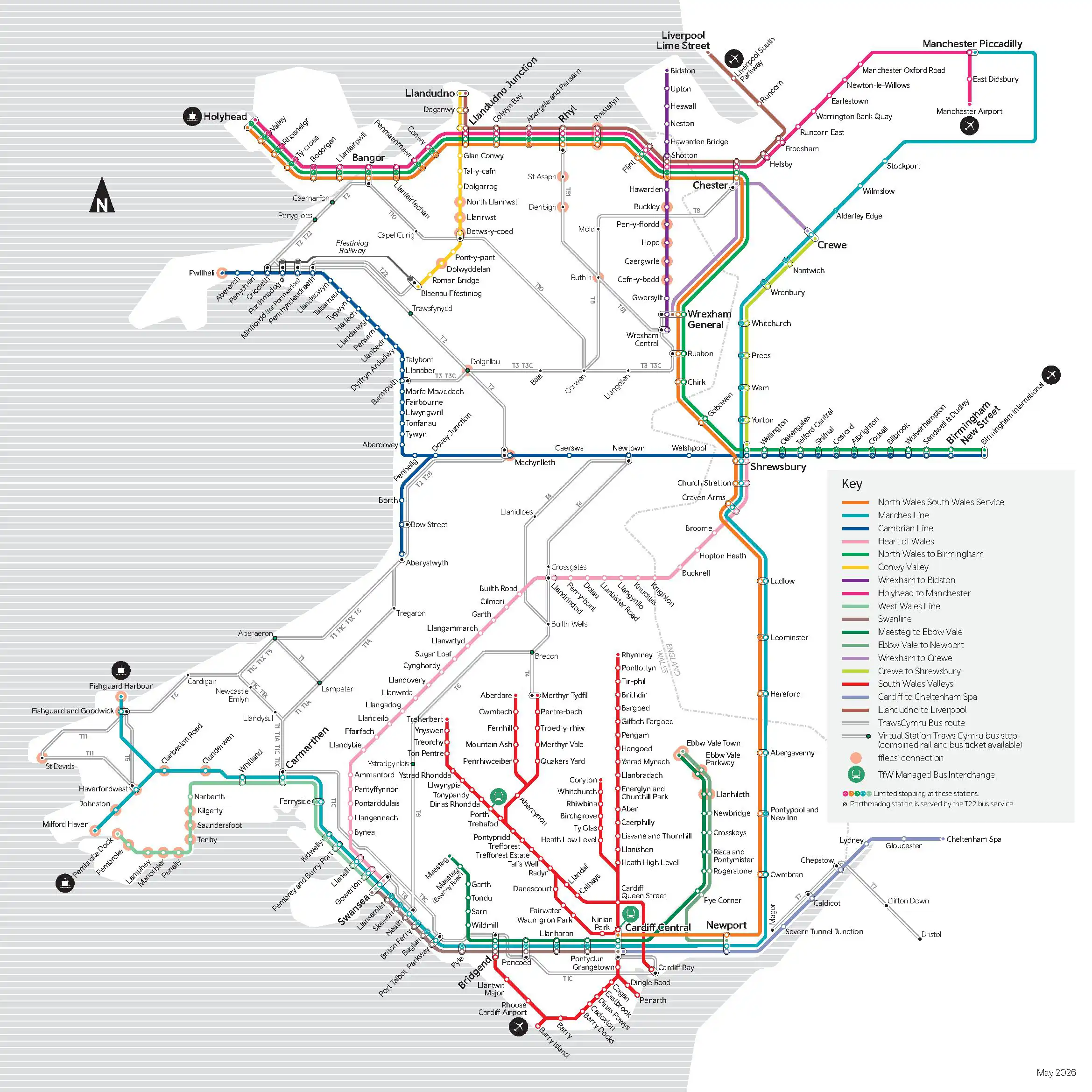
National network map | Open as PDF
Valley Lines network map
Our Valley Lines network map can help you plan your journey in the beautiful South Wales valleys. This historic coal-mining region is now a haven for nature with breathtaking views and excellent rail links. From the train, why not continue your journey by bike or on foot? This map highlights commuter routes connecting Cardiff with destinations like Merthyr Tydfil, Aberdare, Treherbert, and Rhymney.
Not sure where you want to go in and around Wales? We can help - plan your journey from start to finish on our website. All that’s left to do is set off and begin your Welsh adventure by train.

Valley Lines network map | Open as PDF
Frequently asked questions
Where can I find a map of all train stations in Wales?
You can view and download the complete map of all Welsh railway stations directly from this page. We provide both a National Network Map and a dedicated South Wales Valley Lines map in PDF format.
Does the Transport for Wales network map show bus routes?
Yes, our National Network Map highlights key long-distance TrawsCymru bus routes that integrate seamlessly with our rail services, helping you reach destinations beyond the railway line.
How far into England do Transport for Wales trains go?
Our rail network extends beyond the Welsh borders. The TfW map includes direct routes to major English stations such as Manchester Piccadilly, Liverpool Lime Street, Birmingham New Street, and Cheltenham Spa.
Are there physical copies of the TfW network map available?
Yes. While you can download the PDF maps here to print at home or save to your phone, large printed network maps are also displayed at all staffed Transport for Wales stations.
How do I check if my route is disrupted today?
The network map shows our standard scheduled routes. For live service updates, platform alterations, or disruption alerts, we recommend checking the Journey Check tool on our website or using the TfW app before you travel.
Do you have a map showing which stations have step-free access?
While our standard network map shows all routes, you can find detailed station accessibility information, including step-free access and facility maps, on the dedicated 'Stations' page of the TfW website.
-
Did you know?Join our customer panelShare your views and help shape the way Wales travels.Have your say